يوم 1 سبتمبر
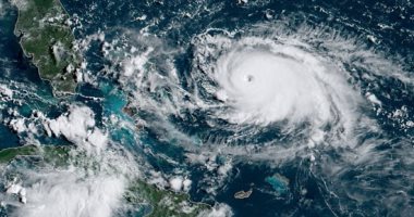
NOAA's #GOESEast spotted lightning in the eye of #HurricaneDorian this morning. The now catastrophic Cat. 5 storm is expected to bring life-threatening storm surge and very heavy rainfall to the Abaco Islands and Grand Bahama through Monday. More: https://t.co/hGBv8RfDYM pic.twitter.com/dDxjoQjoJD
— NOAA Satellites (@NOAASatellites) September 1, 2019
يوم 31 أغسطس
Severe #HurricaneDorian, seen in this "sandwich loop" from NOAA's #GOESEast, is heading for the northwestern #Bahamas where the Cat. 4 storm is expected to bring life-threatening storm surge and devastating winds. Latest updates from the @NHC_Atlantic: https://t.co/cJtAELwt0H pic.twitter.com/D4jMyuYkWb
— NOAA Satellites (@NOAASatellites) August 31, 2019
Cameras outside the @Space_Station captured views of #HurricaneDorian at 11:28am ET as it churned over the Atlantic Ocean. With winds of 145 mph, the storm may approach Category 5 hurricane status, according to the National Hurricane Center. Take a look: https://t.co/W0pFMatz8P pic.twitter.com/qrFNTReumK
— NASA (@NASA) August 31, 2019
30 أغسطس
On this #FullDiskFriday, both #GOESWest and #GOESEast are keeping a close eye on extremely dangerous #HurricaneDorian from 22,300 miles in space. #Dorian is now a Cat. 3 storm with maximum sustained winds of 115 mph, according to the @NHC_Atlantic. More: https://t.co/Uirlt2hAYA pic.twitter.com/R6Vmp5mOyd
— NOAA Satellites (@NOAASatellites) August 30, 2019
Evening RT: Using satellite imagery from the @NASARain Constellation to diagnose the evolution of cloud and precipitation structure in Hurricane #Dorian >>https://t.co/j6ixdbrhpb pic.twitter.com/ApElVQ8UBm
— NASA SPoRT (@NASA_SPoRT) August 30, 2019


